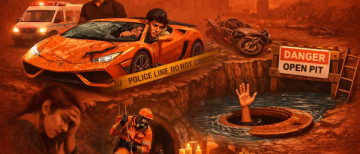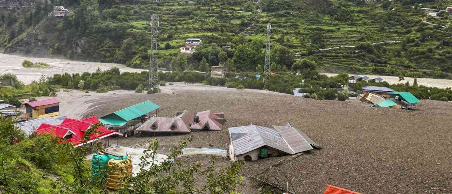

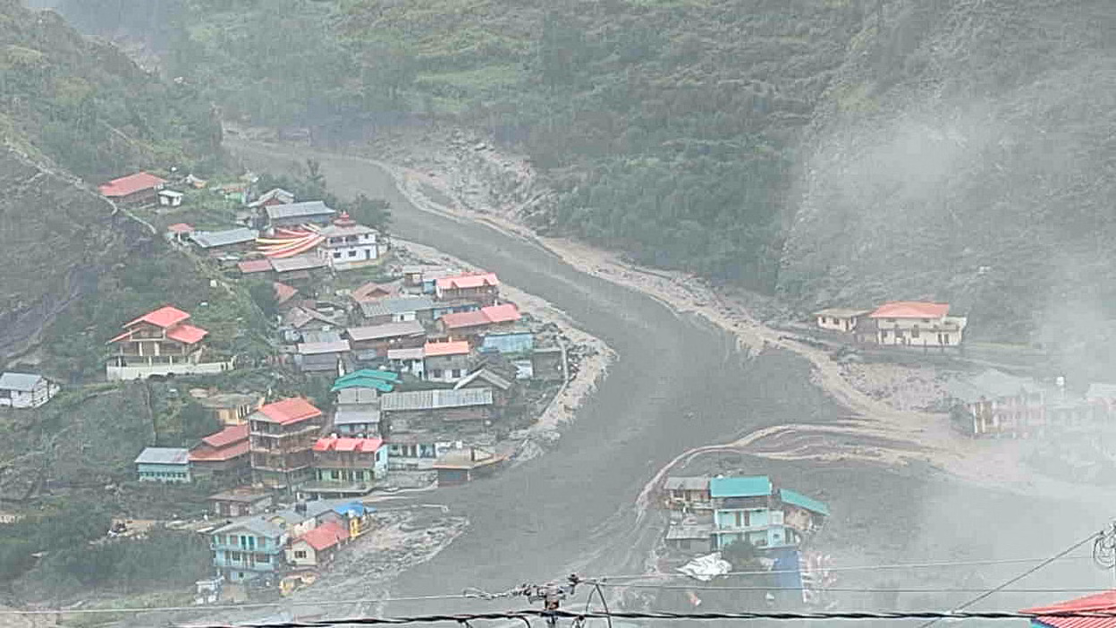
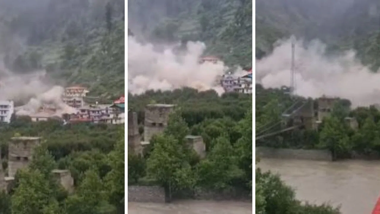
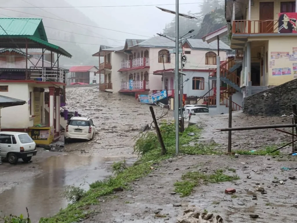
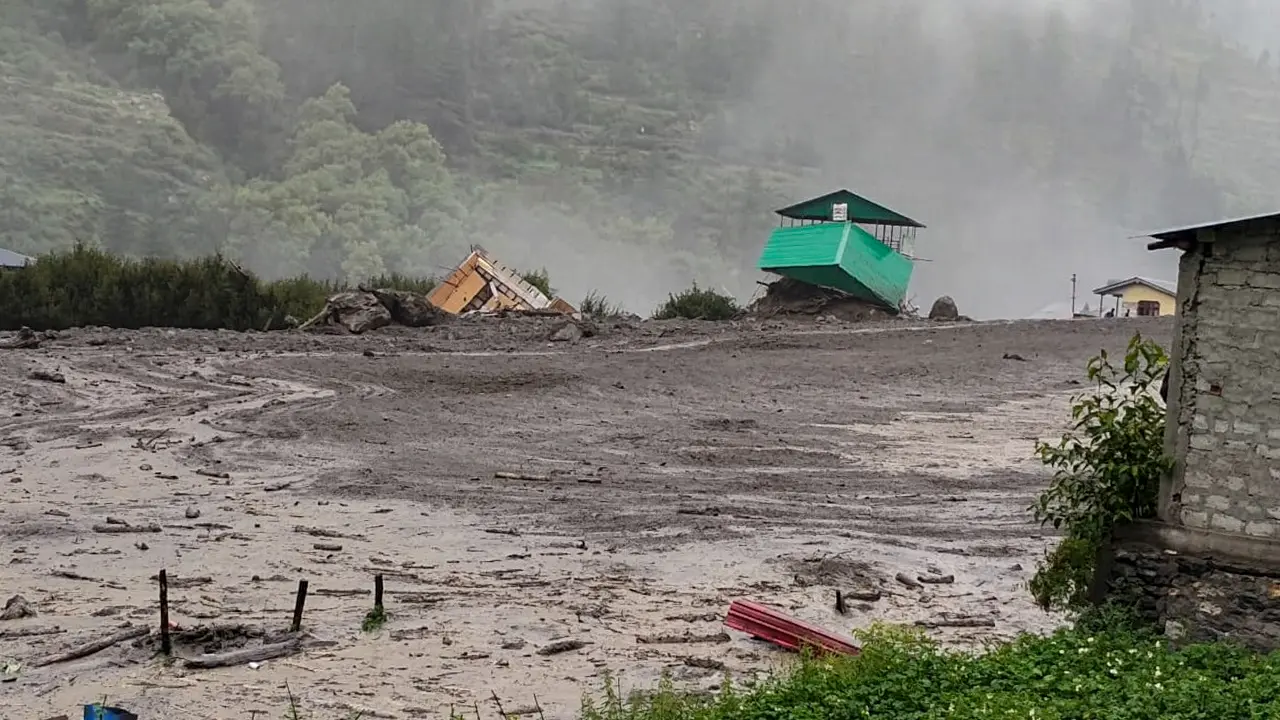
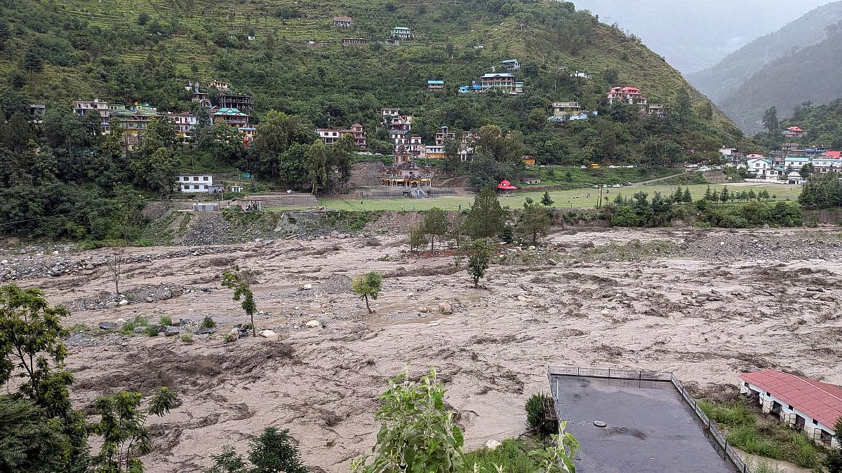
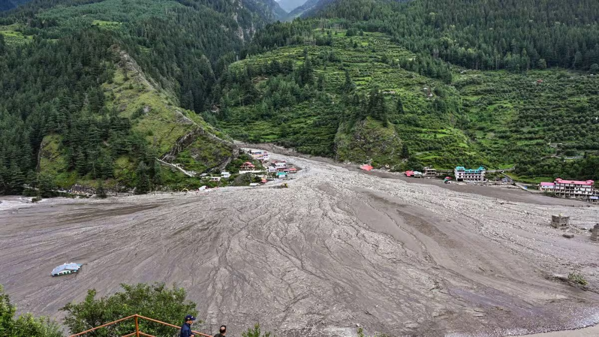
On August 5, 2025, the serene Himalayan hamlet of Dharali, nestled in Uttarakhand’s Harsil valley, was transformed into a site of devastation. In minutes, the Kheerganga River—normally a modest mountain stream—swelled into a furious torrent. Water, mud, uprooted trees, and debris tore through the picturesque village, sweeping away homes, hotels, the only bridge to nearby Harsil, and lives. Forty to fifty buildings were obliterated, five lives confirmed lost, more than 100 people missing, and hundreds displaced. Nine of the missing were army personnel. This disaster—whether triggered by heavy rain, a glacial lake breach, or a combination of factors—has once again revealed the fragile relationship between human ambition and Himalayan reality.
This is not an isolated tragedy. It is the latest in a string of disasters—Kedarnath 2013, Chamoli 2021, Joshimath 2023, Himachal floods 2023, Sikkim glacial lake outburst 2023, Kedarnath floods 2024—that expose how poorly India has learned from its past. Dharali’s story is a painful blend of scientific uncertainty, poor planning, unchecked development, and ignored warnings. Each time, the government promises better early warning systems, stricter building codes, and climate-resilient infrastructure. Each time, little changes.
A Village at the Crossroads of Nature and Risk
Dharali lies 2,680 meters above sea level, 18 km from Gangotri, a sacred Char Dham site. Its hotels, guesthouses, and homes—many built directly on the riverbank—many built illegally, narrowing the river’s natural course, cater to pilgrims and tourists seeking rest before or after their journey to the Gangotri shrine.
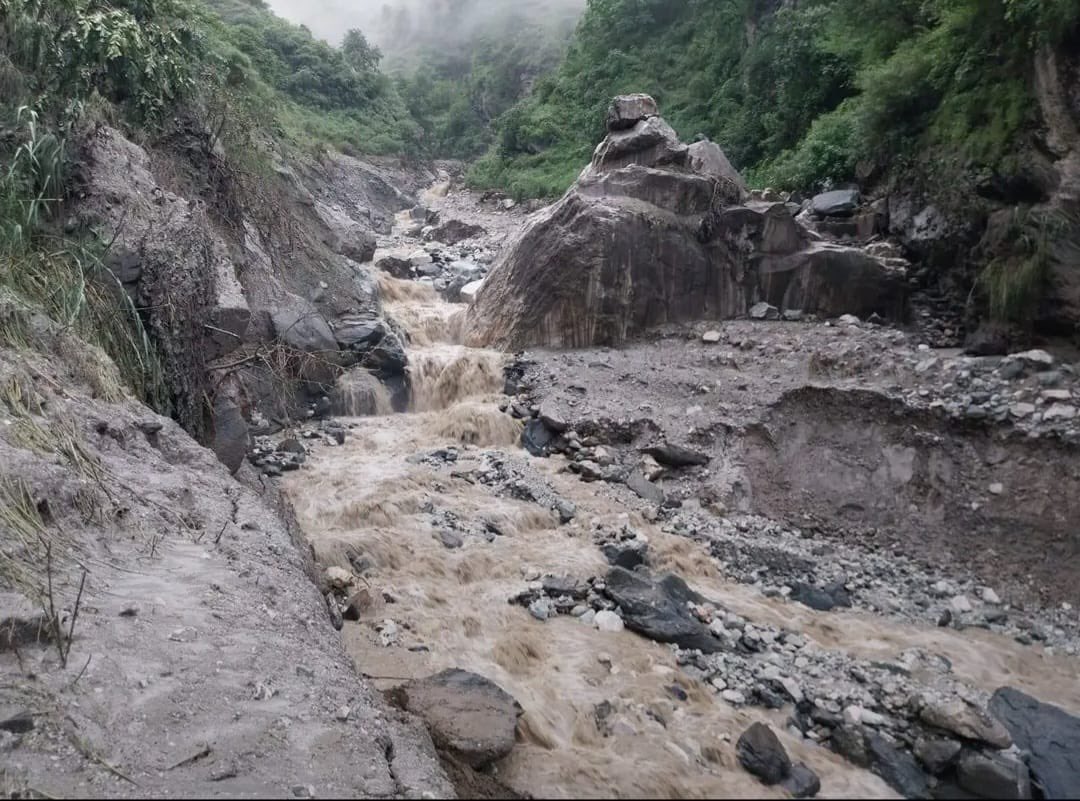
Experts suspect multiple possibilities: heavy rainfall high upstream, perhaps near 12,000 feet; the breach of a small glacial lake; or an overloaded slope giving way, sending mud and debris racing downhill. In the steep gradient between source and settlement—about 4,000 feet in drop—the energy of that flow multiplied exponentially.
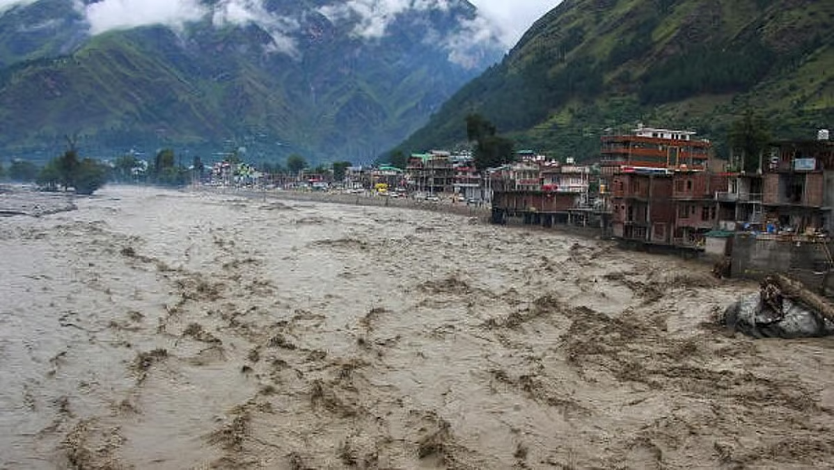
On that August afternoon, a sudden surge of water tore through the settlement, demolishing structures and inundating the area with thick mud, silt, uprooted trees, and debris, as shown in ISRO satellite imagery. The floodwaters also reached an Army base near Harsil. Landslides blocked rescue teams as the national highway caved in at multiple points.
The India Meteorological Department (IMD) had issued warnings for heavy to extremely heavy rain from August 1, but Uttarkashi’s rainfall totals were below average for the season. On the day of the disaster, the district recorded 32 mm of rain—double the normal for that date, but far below the 100 mm/hour threshold for a defined cloudburst. This mismatch has led experts to suspect other triggers, including a glacial lake outburst flood (GLOF)—a sudden release of water from a high-altitude glacial lake—or a combination of moderate rain with saturated, unstable slopes.
When Science Meets Uncertainty
The Dharali disaster underscores a key scientific reality: not all flash floods come from cloudbursts, and not all intense rains cause flash floods. The Himalayan landscape is shaped by a complex interplay of rainfall intensity, slope steepness, soil saturation, debris availability, and geological instability.
-
Cloudbursts: Defined by IMD as at least 100 mm of rain in an hour over 10 sq km. These are highly localized and may go unrecorded if no weather station is nearby. Dharali’s nearest automatic weather station, 7 km away, recorded no such event.
-
Glacial triggers: The region contains 1,266 glacial lakes, 13 of them classified as high-risk. A GLOF, as in Chamoli 2021, can unleash millions of cubic meters of water without a drop of rain.
-
Fragile geology: The Himalayas are geologically young, earthquake-prone, and structurally weak. Continuous blasting for roads and tunnels worsens slope instability.
-
Saturated soils: Even low-intensity rain can trigger landslides and flash floods when slopes are already weakened.
This unpredictability makes early warning systems harder to design. While heavy rain can be forecast, whether it will cascade into a flash flood is far less certain.
The Man-Made Multiplier: Development at Any Cost
Since Uttarakhand became a separate state in 2000, the government has marketed its natural beauty and religious heritage aggressively. Tourist arrivals have exploded from 1.11 crore in 2000 to nearly six crore in 2023. To accommodate this influx, the road network has been widened massively—nowhere more controversially than along the Char Dham route.
The Gangotri Highway widening project, approved in 2024 despite strong local opposition, required felling thousands of deodar trees and slicing vertically into unstable slopes. It violated both the Supreme Court-appointed Ravi Chopra Committee’s recommendations and the Eco-Sensitive Zone notification that has applied to the Uttarkashi–Gaumukh stretch since 2012.
In many towns—Mussoorie, Nainital, Almora, Joshimath—riverside hotels and resorts rise directly on floodplains, flouting court orders and National Green Tribunal bans on construction within 50–100 metres of a river. This illegal expansion not only constricts natural drainage channels but also places human lives directly in harm’s way when water levels surge.
Large-scale deforestation, indiscriminate blasting for tunnels and hydropower, muck dumping into rivers, and altered drainage patterns have stripped the mountains of their natural resilience. ISRO recorded over 11,200 landslides in Uttarakhand between 1988 and 2022; the Geological Survey of India says 72 percent of the state is landslide-prone.
Sacred Geography, Unsacred Policies
The Gangotri–Kedarnath–Badrinath–Yamunotri circuit, once defined by slow, seasonal pilgrimages, is now marketed as a year-round religious tourism product. Today, helicopters buzz over Kedarnath every few minutes. In Sonprayag, multi-storey parking lots stand on unstable riverbeds. Mass tourism has turned sacred spaces into crowded fairgrounds, replacing spiritual quiet with infrastructure noise.
Pilgrims demand urban-level amenities, pushing for wider roads, helicopter access, and luxury stays, even in ecologically sensitive zones. Kedarnath, with a comfortable capacity of 1,000, sometimes hosts 20–30 times that number daily.
The result is a collision of devotion and degradation: sacred valleys echoing with helicopter blades, rivers choked with plastic, and forests replaced by concrete. As one local leader warned before the Harsil–Gangotri highway widening in 2024, “We want better roads but not at the cost of our forests and safety.” Her words proved prophetic.
The government’s logic is one of volume: more pilgrims, more tourists, more kilometres of road, with little regard for carrying capacity or ecological thresholds. Political competition fuels this race—footfall is framed as economic success, even as the supporting infrastructure collapses.
Meanwhile, basic services in many mountain villages remain poor. In places like Tejam, women still die on the trek to the nearest hospital, while helicopter packages to Char Dham proliferate. Seasonal pilgrimage revenue rarely funds health or education, fuelling migration out of the hills.
Complex Triggers, Elusive Warnings
The Dharali flood also underlines the scientific complexity of predicting such disasters.
Flash floods often follow intense rain that triggers landslides or debris flows into rivers. But not always. In Chamoli in 2021, millions of cubic metres of water were suddenly released when a glacier chunk collapsed into the Rishiganga. Conversely, heavy rain doesn’t always cause floods—it depends on slope steepness, soil saturation, and whether the debris path reaches a stream.
In fragile, erosion-prone terrain, even low-intensity rainfall can trigger catastrophic events. The Himalayas’ young, seismically active geology makes them inherently more unstable than older ranges. Ongoing roadworks, blasting, and high-traffic loads weaken slopes further.
While heavy rain can be forecast days ahead, predicting whether it will lead to a flash flood remains highly uncertain. Dharali shows that disasters can strike without the telltale “extreme” rainfall data, meaning localised monitoring, community alerts, and land-use restrictions are critical.
Past recommendations—like limiting mountain road widths to 8–10 meters (as in Europe), banning riverside construction, and consulting geologists before large projects—remain largely ignored. Even Eco-Sensitive Zones like the Uttarkashi–Gaumukh stretch see violations.
The Pattern We Refuse to Break
After Kedarnath in 2013, experts urged mandatory geological assessments before construction. After Chamoli, they warned against building in glacial lake outburst risk zones. After Joshimath began sinking in 2023, they called for curbing unregulated development. Yet, roads, hydropower projects, ropeways, and resort complexes keep moving ahead, often without cumulative environmental impact studies.
Supreme Court and NGT orders are ignored. Eco-Sensitive Zone protections are watered down. Compensation for victims becomes a substitute for prevention. “How many times will the government issue warnings, see lives lost, and then repeat the same mistakes?” asks Uttarakhand geologist Y.P. Sundriyal.
A Different Vision: Slower, Smarter, Rooted Development
Amid the gloom, alternative models exist. In Sarmoli near Munsyari, women-led collectives like Maati Sangathan have built a community-based ecotourism economy tied to farming, weaving, and conservation. It’s proof that economic opportunity need not come at ecological cost.
Traditional Himalayan architecture—stone, mud, and timber homes placed above flood lines—embodies centuries of disaster wisdom. Modern planning could integrate these lessons rather than replace them with unstable concrete blocks.
What Must Change Now
The choice is not between development and preservation—it is about choosing development that works with the mountains, not against them. Traditional Himalayan architecture, built from stone, mud, and wood, stood above flood lines and adapted to seismic shifts. Communities like Sarmoli near Munsyari show that ecotourism can be regenerative—integrating farming, crafts, and conservation without overloading ecosystems.
Policy shifts must include:
-
Strict enforcement of construction bans within river basins,floodplains and landslide-prone zones
-
Limit road width in hill states to 8–10 metres, as practised in Europe, to reduce slope destabilisation.
-
Mandating geotechnical studies before any major infrastructure project
-
Comprehensive glacial lake monitoring with real-time satellite feeds and ground verification.
-
Shift tourism models toward smaller, regulated, community-led operations that keep profits local and reduce pressure on hotspots like the women-run ecotourism collective in Sarmoli, Munsyari.
-
Integrate carrying capacity studies into pilgrimage planning — regulating numbers to match infrastructure and ecological tolerance.
-
Declaring heritage zones in ecologically fragile pilgrimage routes
-
Strictly enforcing ESZ and NGT rules without political dilution
-
Invest in decentralised disaster readiness: local early warning systems, evacuation routes, and stockpiled relief materials in every high-risk valley.
Above all, mountain development must slow down. As environmentalist Sunil Kainthola says, “In the Himalayas, the walk is not just a journey—it is a discipline. You don’t conquer the trail. You adapt to it.”
Will We Finally Listen?
Every Himalayan disaster is called a “wake-up call”, yet the alarm keeps ringing into deaf ears. Dharali is not just a village in mourning—it is a warning to the entire Himalayan arc. The choice is stark: slow down and adapt, or keep pushing until the mountains push back harder.
The Himalayas are not against development; they are against disregard. They demand patience, humility, and respect for limits. To continue on the current path is to invite more Dharalis, more Kedarnaths, more Joshimaths. But to change course—to treat the mountains as living systems, not construction sites—offers the chance for resilience, safety, and dignity for generations to come.
For now, the people of Dharali wait—some for loved ones, others for help to rebuild. The rest of us should not wait for the next disaster to start asking the right questions.
Views expressed in the above piece are personal and solely those of the author. They do not necessarily reflect Vygr’s views.
With inputs from agencies
Image Source: Multiple agencies
© Copyright 2025. All Rights Reserved. Powered by Vygr Media.