
 By

India's eastern coastline is preparing for another potentially powerful tropical storm as Cyclone Akvan gathers strength over the Bay of Bengal. With the India Meteorological Department (IMD) warning of extremely heavy rainfall, destructive winds and possible coastal flooding, the approaching cyclone has raised concerns across Andhra Pradesh, Tamil Nadu and neighbouring states.
Cyclone Akvan is forecast to intensify into a very severe cyclonic storm before approaching the Andhra Pradesh coast around November 20. Weather officials have warned that wind speeds could reach 120–130 kmph, with gusts touching 145 kmph. Several coastal districts are also likely to experience intense rainfall, thunderstorms and rough weather conditions.
The developing storm is particularly concerning because it comes just weeks after Cyclones Arnab and Murasu affected parts of India's eastern coastline, leaving agricultural damage and significant economic losses behind.
As authorities prepare for another weather emergency, here is everything to know about Cyclone Akvan, its expected landfall, affected states, rainfall predictions and the meaning behind its unusual name.
Cyclone Akvan Latest Update: Where Is the Storm Right Now?
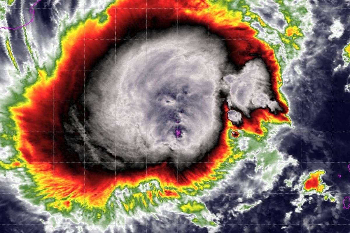
According to the IMD's November 17 bulletin, Cyclone Akvan was positioned over the central parts of the south and adjoining west-central Bay of Bengal.
At approximately 5:30 am on November 17, the weather system was located around:
-
610 km east of Chennai, Tamil Nadu
-
630 km northeast of Trincomalee, Sri Lanka
-
660 km southeast of Machilipatnam, Andhra Pradesh
-
670 km south-southeast of Visakhapatnam, Andhra Pradesh
-
790 km south of Gopalpur, Odisha
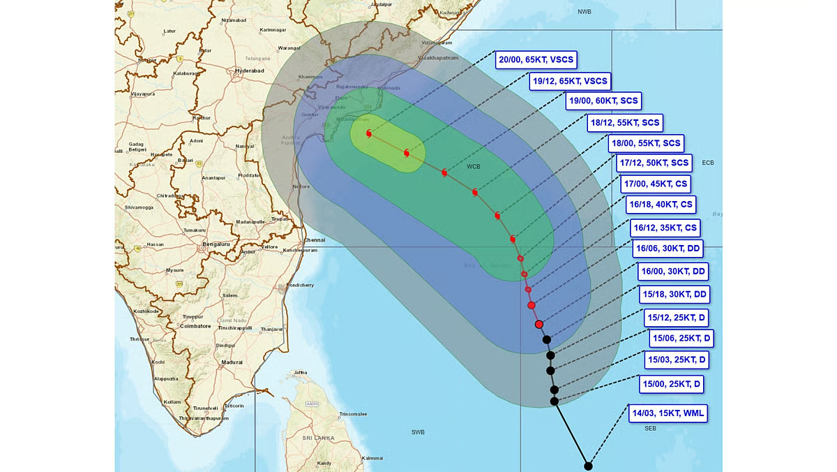
The cyclone is expected to move north-northwestwards over the coming days, gradually strengthening as it approaches the eastern coastline.
Meteorological projections indicate that the system could intensify into a severe cyclonic storm by the evening of November 17, followed by further strengthening into a very severe cyclonic storm around the morning of November 19.
Its movement and intensity will remain important factors in determining the extent of rainfall and wind-related damage across the affected states.
Cyclone Akvan Landfall Date and Location: When Will It Hit Andhra Pradesh?
One of the biggest concerns surrounding Cyclone Akvan is its expected landfall along the Andhra Pradesh coastline.
According to the IMD's forecast issued on November 17, the storm is likely to cross the Andhra Pradesh and Yanam coasts between Nellore and Tuni around noon on November 20.
By the time it reaches the coastline, Akvan is expected to have developed into a very severe cyclonic storm.
The forecast suggests sustained wind speeds of approximately 120–130 kmph, with maximum gusts reaching 145 kmph.
Such powerful winds can damage houses, uproot trees, disrupt electricity infrastructure, damage communication networks and affect transportation services.
Coastal communities, particularly those living in vulnerable and low-lying areas, may face additional risks from intense rainfall, strong winds and rising sea levels.
However, the exact landfall location and intensity can change as the cyclone progresses. Residents should therefore follow the latest official IMD bulletins rather than relying entirely on early predictions.
How Strong Will Cyclone Akvan Become?
The IMD expects Cyclone Akvan to undergo significant intensification before reaching India's eastern coastline.
The system is forecast to progress through different intensity categories, potentially becoming a severe cyclonic storm before strengthening further into a very severe cyclonic storm.
The expected wind speeds highlight the seriousness of the developing weather threat.
| Cyclone Parameter | Expected Conditions |
|---|---|
| Expected landfall | November 20, 2026 |
| Likely landfall region | Between Nellore and Tuni |
| Expected landfall time | Around noon |
| Sustained wind speed | 120–130 kmph |
| Maximum wind gusts | Up to 145 kmph |
| Expected intensity | Very severe cyclonic storm |
| Heavy rainfall threat | November 19–20 |
Apart from powerful winds and torrential rainfall, storm surge is another major concern.
A storm surge occurs when strong cyclone winds push seawater towards the coastline, temporarily raising sea levels above normal tidal conditions.
The IMD has warned of a possible storm surge of approximately 1–2 metres above the normal tide level in vulnerable coastal areas.
Several low-lying districts, including Bapatla, Krishna, West Godavari and Kakinada, could face coastal flooding if these conditions materialise.
Cyclone Akvan Rainfall Alert: Which States Will Be Affected?
Although Andhra Pradesh is expected to face the most direct impact of Cyclone Akvan, its influence could extend across several eastern and southeastern states.
1. Andhra Pradesh
Coastal Andhra Pradesh is likely to experience the strongest effects of the approaching cyclone.
The IMD has warned of extremely heavy rainfall on November 19 and 20. Some locations could receive more than 21 cm of rainfall within 24 hours.
Strong winds, waterlogging, flooding and damage to agricultural fields are among the major concerns.
The situation is particularly sensitive because the state has already experienced significant agricultural losses following Cyclones Arnab and Murasu.
2. Tamil Nadu
Tamil Nadu could experience widespread rainfall as Cyclone Akvan approaches Andhra Pradesh.
According to the IMD, Chennai, Tiruvallur and Chengalpattu are likely to receive heavy rainfall accompanied by thunderstorms and lightning from November 17. Gusty winds reaching 40–50 kmph are also expected.
From November 18, heavy rainfall is likely in additional districts, including:
-
Kanchipuram
-
Ranipet
-
Tiruvannamalai
-
Villupuram
-
Cuddalore
-
Mayiladuthurai
The neighbouring Union Territory of Puducherry could also experience heavy rainfall.
However, whether Tamil Nadu receives widespread or particularly intense rainfall will depend on the cyclone's final trajectory, distance from the coastline and surrounding atmospheric conditions.
Weather models, including ECMWF, GFS and GEM, have shown signs of convergence towards a possible track closer to extreme northern Tamil Nadu and southern Andhra Pradesh.
This developing model consensus has attracted attention among weather observers, as even a relatively small change in the cyclone's path could influence rainfall distribution across northern Tamil Nadu.
Nevertheless, model projections are not confirmed landfall forecasts, and further updates will be necessary to understand the actual rainfall potential.
3. Odisha
Odisha is also preparing for possible rainfall and strong winds associated with Cyclone Akvan.
The weather department has issued orange and yellow rainfall warnings for different districts between November 18 and November 21.
Orange alerts indicate expected rainfall of approximately 12–20 cm, while yellow alerts correspond to around 7–11 cm.
The districts under particular watch include Ganjam, Gajapati, Kandhamal, Rayagada, Koraput, Malkangiri and Puri.
Authorities have started preparations to minimise the potential impact, including deploying 74 rescue teams and initiating early evacuations in vulnerable southern districts.
4. West Bengal
Parts of southern West Bengal could also experience heavy rainfall as the weather system moves towards the eastern coastline.
South 24 Parganas, Purba Medinipur, Paschim Medinipur and Jhargram are among the districts likely to receive heavy rain.
The intensity and distribution of rainfall will depend on the cyclone's movement and associated weather conditions.
Will Cyclone Akvan Bring Heavy Rain to Chennai?
The possibility of significant rainfall in Chennai is one of the most closely watched aspects of Cyclone Akvan.
Although the system is expected to make landfall farther north along the Andhra Pradesh coast, Chennai and surrounding districts could still experience substantial rainfall.
The IMD has already indicated the possibility of heavy rain, thunderstorms and lightning across Chennai, Tiruvallur and Chengalpattu, along with gusty winds of 40–50 kmph.
Weather models are also showing increasing interest in a track towards extreme northern Tamil Nadu and southern Andhra Pradesh.
However, a northward-moving cyclone does not automatically guarantee widespread or exceptionally heavy rainfall across Chennai.
Rainfall depends on several factors, including the cyclone's distance from the coast, its circulation, moisture availability and the direction of prevailing winds.
Consequently, residents should watch for updated district-level rainfall forecasts rather than assuming that the entire state will experience equally intense rainfall.
Why Is the Cyclone Called Akvan? Meaning and Origin Explained
The name Akvan has also attracted attention, particularly because of its unusual origin.
Unlike the names of some previous cyclones affecting India, Akvan was contributed by Iran as part of the regional cyclone-naming system.
The name has connections to Persian folklore and tradition. It is associated with Akvan Div, a mythical demon-like character featured in the Shahnameh, the celebrated Persian epic written by poet Ferdowsi.
The character is portrayed as a powerful and cunning adversary.
The regional cyclone-naming system, however, does not provide an official translation of the name. Akvan is primarily used as an identifying name for the weather system.
How Are Cyclones Named?
Cyclone names are selected through a coordinated regional system involving 13 countries associated with the World Meteorological Organization and the United Nations Economic and Social Commission for Asia and the Pacific.
A list containing 169 names was compiled in 2020, with countries contributing names in advance.
The Regional Specialized Meteorological Centre (RSMC) in New Delhi selects the next available name sequentially when a qualifying cyclonic storm develops.
This explains why cyclones affecting the same geographical region can have names contributed by different countries.
For instance, Cyclone Arnab was named by Bangladesh, while Cyclone Murasu carried a name contributed by India. Akvan follows the same established naming procedure.
Giving cyclones distinct names makes it easier for meteorological agencies, emergency services, governments and the public to communicate warnings and track individual weather systems.
Cyclone Akvan Raises Concerns After Arnab and Murasu
Another reason Cyclone Akvan is being closely monitored is the recent history of powerful cyclones affecting Andhra Pradesh.
Cyclone Arnab crossed the Andhra Pradesh coast near Yanam on October 28 as a very severe cyclonic storm, with wind speeds reaching approximately 125–135 kmph.
It was followed by Cyclone Murasu, which made landfall near Ongole on November 3 as a severe cyclonic storm.
The back-to-back weather systems brought heavy rainfall, flooding and extensive agricultural damage.
According to estimates reported by state authorities, the combined losses in Andhra Pradesh were close to Rs 7,000 crore, with lakhs of acres of crops affected. The state also sought financial assistance from the Centre.
The arrival of another potentially powerful cyclone within such a short period could create additional challenges for farmers, coastal residents and disaster management agencies.
Cyclone Akvan: Safety Precautions and Government Preparedness
With Cyclone Akvan potentially bringing destructive winds, heavy rainfall and coastal flooding, precautionary measures are essential.
Residents in vulnerable coastal areas should follow official evacuation instructions and avoid unnecessary travel during severe weather conditions.
Some important precautions include:
-
Secure loose objects, outdoor furniture and temporary structures that could be displaced by strong winds.
-
Keep essential medicines, drinking water, food, flashlights and emergency supplies ready.
-
Avoid standing near electric poles, damaged power lines and large trees during strong winds.
-
Fishermen should strictly follow official restrictions and avoid venturing into rough seas.
-
People living in low-lying coastal areas should remain prepared for possible evacuation.
-
Keep mobile phones charged and monitor official weather updates and local administration announcements.
Authorities in Andhra Pradesh and neighbouring states will need to monitor the cyclone's movement closely and ensure that rescue and relief arrangements are ready before landfall.
Cyclone Akvan's Next Few Days Will Be Crucial
Cyclone Akvan is emerging as a significant weather threat for India's eastern coastline, with Andhra Pradesh expected to face the most direct impact around November 20.
The possibility of winds reaching 145 kmph, extremely heavy rainfall and storm surges makes the approaching system particularly concerning.
Tamil Nadu, Odisha and parts of West Bengal could also experience heavy rainfall, thunderstorms and gusty winds, although the exact impact will depend on the cyclone's evolving trajectory.
Following the damage caused by Cyclones Arnab and Murasu, the approaching storm presents another serious challenge for the region.
Over the next few days, changes in Akvan's intensity, movement and landfall location will be crucial in determining the scale of its impact.
Residents should remain alert, follow official IMD warnings and prioritise safety as the cyclone approaches India's eastern coast.
© Copyright 2026. All Rights Reserved. Powered by Vygr Media.