

 By
By 
New Delhi, September 4, 2026: Delhi-NCR was battered by heavy rain and thunderstorms on Friday, disrupting normal life, flooding roads and affecting flight operations at Indira Gandhi International Airport. The India Meteorological Department (IMD) escalated its weather warning for Delhi to a red alert, cautioning residents about intense rainfall, thunderstorms, lightning and strong winds.
The spell of rain intensified through the afternoon after the national capital began the day under cloudy skies. Several parts of Delhi witnessed waterlogging, while adjoining areas of the National Capital Region, including Noida, Ghaziabad and Gurugram, also reported inundated roads and difficult traffic conditions. The weather disruption came as Delhi was observing Janmashtami, leaving many people caught in sudden downpours while heading out for celebrations.
The latest weather system has also disrupted air travel. Nine flights were diverted between 3:30 pm and 4:30 pm, with four flights sent to Jaipur, four to Lucknow and one to Ahmedabad. Delhi airport also reported water accumulation around its approach roads and forecourt areas, adding to the difficulties faced by passengers.
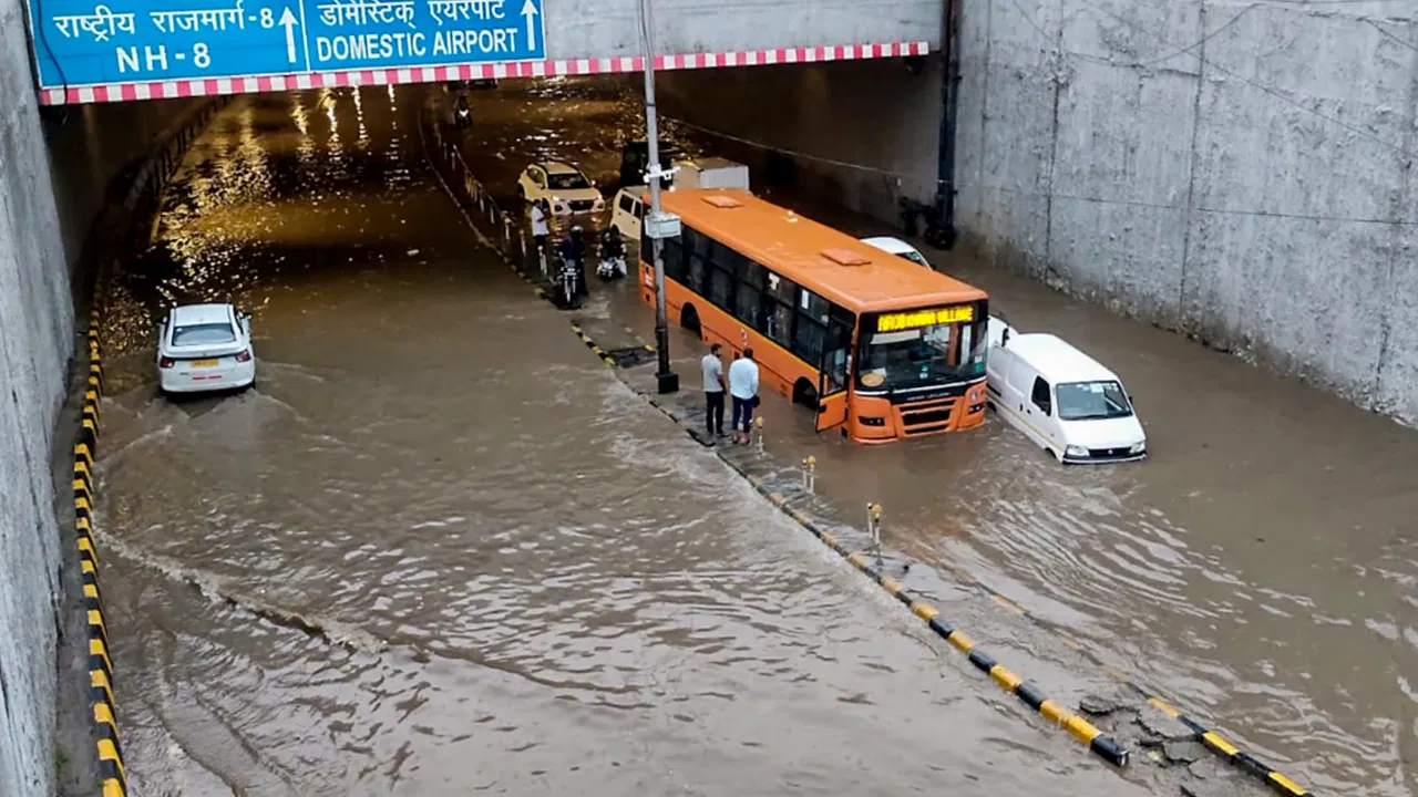
Delhi Rain Intensifies, IMD Issues Red Alert
The IMD's warning came as rainfall activity picked up across the capital. The weather department forecast light to moderate rain accompanied by thunderstorms and lightning in many areas, with isolated pockets likely to receive heavy rainfall.
Another spell was expected between 5 pm and 8 pm, with heavy rain possible at isolated locations. The forecast also warned of strong winds in the range of 40-50 kmph, gusting up to 60 kmph, raising concerns over difficult travel conditions and the possibility of falling branches and other weather-related hazards.
The impact was particularly visible in parts of West Delhi. Areas including Gandhi Market in Sagarpur experienced waterlogging, while several residential colonies saw roads submerged under rainwater. Vehicles were seen moving through flooded stretches as the downpour continued.
Noida and Ghaziabad were placed under an orange warning, while Gurugram was not under a warning in the afternoon update. However, the broader NCR remained vulnerable to further rain and thunderstorms as the weather system continued to influence the region.
72.2 mm Rainfall in Palam in Three Hours
The intensity of Friday's downpour varied sharply across Delhi. Palam recorded the highest rainfall, receiving 72.2 mm between 2:30 pm and 5:30 pm.
Narayana recorded 54 mm during the same period, followed by Janakpuri with 48.5 mm, Lodhi Road with 34.6 mm and Safdarjung with 32.6 mm. Pusa recorded 29 mm, while Jharoda Kalan, Ridge, Chhatarpur and Ayanagar recorded 25 mm, 20 mm, 15 mm and 12 mm respectively.
The sharp increase in rainfall over a short period translated into waterlogging across several neighbourhoods. At the airport, accumulated water was reported around the approach road and forecourt. Airport authorities said the water was cleared shortly afterwards and that measures were being taken to keep operations running.
The situation nevertheless highlighted how quickly intense rainfall can disrupt movement in the capital, particularly when heavy showers arrive within a concentrated period.
#WATCH | Delhi: Waterlogging in parts of the city following rainfall. Visuals near Subroto Park. pic.twitter.com/4844lmNlS7— ANI (@ANI) September 4, 2026
Delhi Airport Waterlogging, Nine Flights Diverted
Air travel was among the biggest casualties of the deteriorating weather.
Nine flights scheduled to arrive in Delhi were diverted during the peak of the afternoon weather disruption. Four were redirected to Jaipur, four to Lucknow and one to Ahmedabad.
Among the flights diverted to Lucknow were services arriving from Bengaluru, Ludhiana, Indore and Hyderabad. One Bengaluru-Delhi flight arrived in Lucknow at 4:37 pm, while flights from Ludhiana, Indore and Hyderabad reached the airport later in the afternoon.
Airlines warned passengers that schedules could be affected by the adverse weather. Travellers were advised to check their flight status before leaving for the airport and to allow additional time for road travel because of slower traffic conditions.
The combination of heavy rainfall, poor visibility, water accumulation and difficult road conditions created challenges not only for aircraft operations but also for passengers trying to reach or leave the airport.
Traffic Hit Across Delhi-NCR
The rain also disrupted road travel across the National Capital Region. Several roads in Delhi and Gurugram were inundated, with traffic snarls reported at prominent locations.
In Gurugram, heavy waterlogging was reported around Cyber City, Shankar Chowk and Sheetla Mata Road, affecting movement in some of the city's busiest commercial and commuting zones. Parts of Connaught Place and Lutyens' Delhi were also affected by the downpour.
While some reports indicated that major roads had not yet experienced widespread traffic gridlock at the time of the afternoon assessment, prolonged rainfall threatened to worsen waterlogging and congestion, particularly in low-lying areas.
The situation was fluid as the rain continued, meaning conditions could change rapidly depending on the intensity and duration of subsequent showers.
Why Is Delhi Receiving Such Heavy Rain?
The latest spell is linked to an active monsoon system over north-central India. A well-marked low-pressure area over northeast Madhya Pradesh and adjoining regions has been contributing to significant rainfall across parts of central and northern India.
The system's influence has extended into Delhi-NCR, producing the combination of cloud cover, heavy showers, thunderstorms and strong winds.
Delhi's unusually wet August has also provided a backdrop to the latest spell. The capital received 354.1 mm of rainfall between August 1 and August 30, substantially above the month's long-period average of 233.1 mm.
Delhi also recorded above-normal August rainfall in 2025 and 2024, when the city received 400.81 mm and 390.3 mm respectively. Since 2011, August rainfall has exceeded the long-period average in Delhi only six times — in 2012, 2013, 2020, 2024, 2025 and 2026.
The latest rains therefore come after an already wetter-than-usual period for the capital.
Heavy Rain Disrupts Life Across North India
The weather disturbance was not confined to Delhi. Several parts of northern India experienced heavy rainfall, with Uttar Pradesh, Bihar, Himachal Pradesh, Rajasthan, Punjab and Haryana also facing significant weather-related disruption.
Uttar Pradesh was already dealing with a serious flood situation, with around 3.53 lakh people across 26 districts affected. Sultanpur recorded 16.4 mm of rain, followed by Gorakhpur at 10.4 mm, Aligarh at 9.4 mm and Shahjahanpur at 8.6 mm.
The state government had deployed 1,634 flood outposts, 1,697 boats and motorboats, 1,068 medical teams and 1,312 flood shelters in affected areas.
Several major rivers were also running high. The Ganga crossed the warning level at Varanasi and was flowing above the danger level, while the Ghaghra was above the danger mark at Ballia.
In Himachal Pradesh, rainfall resulted in the closure of 102 roads. Mandi accounted for the largest share of blocked roads with 46, followed by Kullu with 22, Sirmaur with 11 and Kangra with eight. Other affected districts included Una, Chamba, Shimla, Solan, Lahaul-Spiti and Bilaspur.
Rajasthan also witnessed intense rainfall, with Khandar in Sawai Madhopur recording 130 mm in the 24 hours ending Friday morning. Heavy to very heavy rainfall was expected at isolated places in eastern and southeastern parts of the state.
Bihar, meanwhile, faced flood-like conditions in several districts as rivers swelled following persistent rainfall in Nepal and neighbouring Jharkhand. The Ganga, Gandak, Kosi, Burhi Gandak, Bagmati, Punpun and Ghaghra rivers were reported to have inundated several areas.
More Rain Likely on Saturday
The weather threat is not expected to disappear immediately.
The IMD has forecast another day of significant rainfall over the Haryana-Chandigarh-Delhi region on Saturday, September 5. Delhi's local forecast also points to moderate rain, thunderstorms and lightning at different times during the day.
Western Uttar Pradesh, including several NCR areas, is also under a heavy-rain warning for September 4 and 5.
The weather is expected to gradually become less intense after Saturday. No heavy-rain warning was indicated for Delhi from September 6 onward, although light rain or drizzle may continue.
For residents, commuters and air travellers, the immediate priority remains caution. With waterlogging already affecting roads and airport access and thunderstorms capable of producing sudden strong winds, travel plans may need to account for rapidly changing conditions.
Friday's rainfall once again showed how quickly a concentrated spell of monsoon rain can bring parts of Delhi-NCR to a standstill — from flooded roads and disrupted commutes to waterlogged airport approaches and diverted flights. With another wet day forecast, the capital and surrounding regions remain on alert.
With input from agencies
Image Source: Multiple agencies
© Copyright 2026. All Rights Reserved. Powered by Vygr Media.